
The Mullaghmore Loop Hiking Trail is a popular destination for hikers and nature enthusiasts visiting The Burren, County Clare, Ireland. This guide provides a comprehensive overview of the trail, including information on its history, terrain, difficulty level, and things to see along the way.
The Mullaghmore Loop Hiking Trail is a part of the Burren National Park, which was established in 1991 to protect the unique flora and fauna of the region. The trail itself is a 7.5 km loop that takes hikers through some of the most stunning landscapes in The Burren.
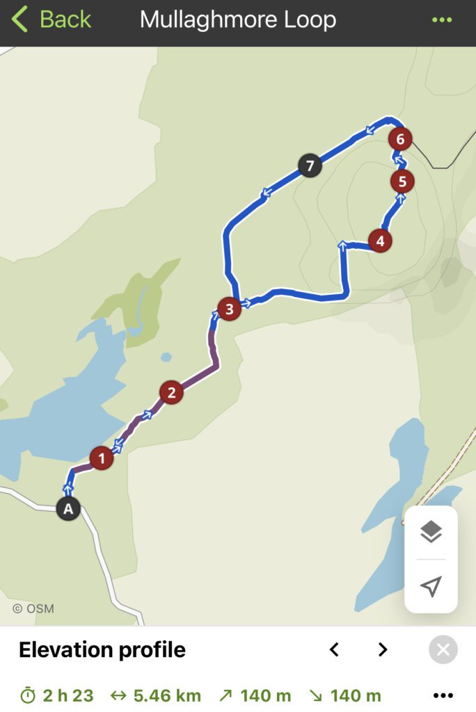
The circular walking route gives hikers the opportunity to see some of the unique flora and fauna of The Burren. The trail passes through limestone pavements, which are home to a variety of rare plants, including the spring gentian, mountain avens, and many different kinds of orchid. The trail also passes by the ruins of an ancient stone fort and a Neolithic tomb, providing a glimpse into the region’s rich history.
Terrain & Difficulty:
The terrain of the Mullaghmore Loop Hiking Trail is diverse, ranging from gentle slopes to steep inclines. The trail is well-marked and easy to follow. The trail also offers panoramic views of the surrounding landscape, including the Cliffs of Moher and Galway Bay.
The Mullaghmore Loop Hiking Trail is considered a moderate-level hike, with some steep inclines and rocky terrain. It is suitable for hikers of all ages and fitness levels, but it is recommended that hikers wear sturdy hiking boots and bring plenty of water and snacks.
You can view the Komoot tour I made for the trail here
If you would prefer to do a less strenuous or time-consuming hike, you could check out the Burren Nature Trail, which is a 40-minute accessible loop through different Burren ecosystems.
Getting There
The Mullaghmore Loop Hiking Trail is located in The Burren National Park, near the village of Kilfenora in County Clare, Ireland. The starting and ending point of the 7.5 km loop is the Mullaghmore Car Park, which is located off the R480 road. It is 25km from Ennis, and 70km from Galway, The trailhead is easily accessible by car, and there are also public transportation options available from nearby towns.
Leave a reply
You must be logged in to post a comment.